Click here to download –>Ivatan
Author: jepeurii
Philippine Flowers and Plants

HELICONIA, HANGING LOBSTERCLAW (HELICONIA ROSTRATA). MONTEBELLO VILLA HOTEL, CEBU CITY, PHILIPPINES

MORNING GLORY BUSH (IPOMOEA CARNEA), SAN JUAN STREET, MOLO, ILOILO CITY, PHILIPPINES.

PEACOCK FLOWER (CAESALPINIA PULCHERRIMA), SAN JUAN STREET, MOLO, ILOILO CITY, PHILIPPINES

FLAME TREE (DELONIX REGIA) SAN JUAN STREET, ILOILO CITY PHILIPPINES

ACACIA TREE IN BLOSSOM, MARCH 2013, BAGUMBAYAN, TIGBAUAN, ILOILO PHILIPPINES

GOLDEN SHOWER TREE (CASSIA FISTULA) SILAY, NEGROS OCCIDENTAL, PHILIPPINES. IN THE PHILIPPINES KNOWN AS KANYA PISTULA, LOMBAYONG OR BISTULA.

ORCHID TREE “BAUHINIA”

YELLOW BELLS, YELLOW TRUMPET TREE (TECOMA STANS), RIZAL AVENUE, AREVALO, ILOILO CITY, PHILIPPINES
Source: http://myphilippinelife.com/philippine-trees-and-garden-flowers/
Philippine Water Formations

1. Laguna de Bay (Filipino: Lawa ng Bay; English: Lake of Bay) is the largestlake in the Philippines located east of Metro Manila between the provinces ofLaguna to the south and Rizal to the north. The freshwater lake has a surface area of 911-949 km² (352-366 sq mi), with an average depth of about 2.8 metres (9 ft 2 in) and an elevation of about 1 metre (3 ft 3 in) above sea level. The lake is shaped like a stylized ‘W’, with two peninsulas jutting out from the northern shore. Between these peninsulas, the middle lobe fills the large volcanic Laguna Caldera. In the middle of the lake is the large island of Talim, which falls under the jurisdiction of the towns of Binangonan and Cardona inRizal province.

2. Davao Gulf is a gulf found in Mindanao in the Philippines. It has an area of 308,000 hectares. Davao Gulf cuts into the island of Mindanao from Philippine Sea. It is surrounded by all five provinces in the Davao Region. The largest island in the gulf is Samal Island. Davao City, on the gulf’s west coast, is the largest and busiest port on the gulf. The Bagobo, a tribe known in Davao, are living in the Davao Gulf. With the thrust of Davao City towards Information Technology and IT-Enabled Services (ITES), Davao City and the Davao Gulf area have also earned the moniker Silicon Gulf.

3. Lake Balanan is a lake situated Siaton, Negros Oriental, Philippines. It is a freshwater lake in the forested mountains of the southern portion of the island of Negros, with a shape resembling a figure of eight, the narrowest point between the two main portions of the lake being only 90 metres wide. The lake is surrounded by mountain ranges, and is fed by three tributaries, all located in the northern end. These are the Lamarao Creek at the northeastern corner with two waterfalls, the Balanan Creek at the middle of the northern end with another waterfall, and the Nasig-id Creek at the northwestern end.

4. The Rio Grande de Mindanao, also known as the Mindanao River, is the second largest river system in the Philippines, after the Cagayan River ofLuzon.[1] It is the largest river on the southern island of Mindanao with a drainage area of 23,169 km2 (8,946 sq mi) draining majority of the central and eastern portion of the island. It is also the second longest river in the countrywith a length of approximately 373 km (232 mi). It is an important transportation artery on the island, used mainly in transporting agricultural products and, formerly, timber.

5. Malumpati Cold Springs: Antique
Malumpati Cold Spring is one of the nice places in Pandan. Tourists would frequent this place especially
if it’s hot just for a nice swim in its natural pool of cold spring water.
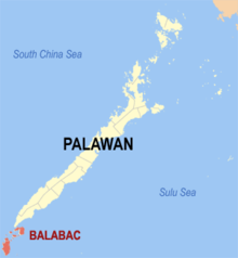
6. The Balabac Strait (Filipino: Kipot ng Balabak) is one of the straits that connects the South China Sea with the Sulu Sea. It separates Balabac Island (Palawanprovince), Philippines, from Balambangan and the Banggi Islands north ofBorneo that are a part of Malaysia‘s Sabah state.
The strait is about 50 kilometers (31 mi) wide with a minimum depth of around 100 meters (330 ft). It was therefore above sea level during the last ice ageand permitted exchange of flora and fauna between Borneo and the Palawans.

7. Tubbataha Reefs (Filipino: BahurangTubbataha) is aprotected area of the Philippines located in the middle of Sulu Sea. The marine and bird sanctuary consists of two huge atolls (named the North Atoll and South Atoll) and the smaller Jessie Beazley Reef covering a total area of 97,030 hectares (239,800 acres; 374.6 sq mi). It is located 150 kilometres (93 mi) southeast of Puerto Princesa City, the capital of Palawan province. The uninhabited islands and reefs are part of the island municipality ofCagayancillo, Palawan, located roughly 130 kilometres (81 mi) to the northeast of the reef.

8. The Bashi Channel is a waterway between Y’Ami Island of the Philippines and Orchid Island of Taiwan. It is a part of the Luzon Strait in the Pacific Ocean. It is characterized by windy storms during the rainy period, June to December.
The Bashi Channel is an important passage for military operations. Both Taiwan and the Philippines dispute the ownership of the waters because both sides say the region lies within 200-nautical-mile from their shores. The channel is also significant to communication networks. Many of the undersea cables that carry data and telephone traffic between Asian countries pass through the Bashi Channel, making it a major point of failure for the Internet. In December 2006, a magnitude 6.7submarine earthquake cut several undersea cables at the same time, causing a major communications bottleneck that lasted several weeks.
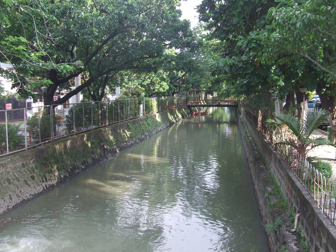
9. Amorsolo Creek Drains water from Amorsolo Street in Makati starting from the area around Makati Medical Center. A section of has been built over by the developers of the Pasay Road on-ramp of the Manila Skyway. Passes through San Lorenzo Villiage and Don Bosco Church.Dumps water into Estero de Tripa de Gallina.

10. Epol Falls is located at Marilog District, Davao City, Philippines in the mountainous area of Barangay Baganihan, homeland of the Matigsalug tribe and is adjacent to Bukidnon and North Cotabato provinces. It is high altitude with some parts reaching 4,000 feet above sea level, cool and pleasant weather where many go for treks, vegetables and just to escape the humid and punishing heat in the lowlands. Barangay Baganihan, Marilog District, Philippines is a place located latitude (7.524850) and longtitude (125.224655) on the map of the Philippines. Epol is an acronym which stands for Everlasting Power of Love Waterfalls.
Landforms in the Philippines

1. Mallig Plains Region is a region in the western part of the province of Isabela. Its name was derived from the rolling terrains or kilometers of plain lands in western Isabela. The municipality of Roxas serves as the business center of the region

2. Compostela Valley (Cebuano: Kawalogang Kompostela) is a province of the Philippines located in the Davao Region inMindanao. The province, called Comval for short, used to be part of Davao del Norte until it was made independent in 1998. It is the fourth newest province of the Philippines, behind Dinagat Islands, Zamboanga Sibugay and Davao Occidental. Its capital isNabunturan. The province borders Davao del Norte to the west, Agusan del Sur to the north, and Davao Oriental to the east. To the southwest lies the Davao Gulf. Its first elected governor was Jose Caballero, formerly a lawyer for a mining group in the province.

3. Mount Agad-Agad is a mountain Located in Iligan City, Philippines which has an estimated height 1,600 feet (490 m) above sea level.
Mount Agad-Agad is very accessible and is good for mountain hikings and overnight campings. It affords a full view of Iligan City by night or day, ideal for the adventurous type, hikers and mountaineers. A small waterfall is featured on the way to the top of the mountain.

4. The Himontagon Hills are a group of hills located in Loay, Bohol, Philippines, about 20 kilometers from the Tagbilaran City. The hill is a very scenic place overlooking the Bohol Sea. Despite its natural beauty, it is not a well known tourist spot and is frequented only by nature photographers. During clear weather, Mount Hibok-Hibok in Camiguin is very visible.

5. Mount Hibok-Hibok is a stratovolcano on Camiguin Island in the Philippines.[1] It is one of the active volcanoes in the country and part of the Pacific ring of fire.

6. The Benham Plateau, also known as the Benham Rise, is a seismically active undersea region and extinct volcanic ridge located in the Philippine Sea approximately 250 km (160 mi) east of the northern coastline of Dinapigue, Isabela.
Under the Philippine Sea lie a number of basins including the West Philippine Basin (WPB), inside of which is located the Central Basin Fault (CBF). The Benham Plateau is located in the CBF and its basement probably represents a micro-continent. Several scientific surveys have been made on the feature to study its nature and its impact on tectonic subduction, including one about its effects on the 1990 Luzon earthquake. The area is claimed, as part of its continental shelf, by the Philippines, which has lodged a claim with the United Nations Commission on the Limits of the Continental Shelf on April 8, 2009 and was approved by the United Nations Convention on the Law of the Sea (UNCLOS) in 2012.

7. Bondoc Peninsula is located in the southeastern part of Quezon Province . Bondoc Peninsula is in Calabarzon Region, southern part of Luzon Island, Philippines. The peninsula consists of 12 municipalities: Agdangan, Buenavista, Catanauan, General Luna, Macalelon, Mulanay, Padre Burgos, Pitogo, San Andres, San Francisco, San Narciso andUnisan.

8. Pantaron Mountain Range, also called the Central Cordillera of Mindanao, Philippines is a mountain range straddling across the provinces of Misamis Oriental, Bukidnon, Agusan del Norte, Agusan del Sur, Davao del Norte and Davao del Sur. The range contains one of the last remaining old growth or primary forest blocks in Mindanao. Major rivers in the island also has their headwaters in the mountain range including Mindanao River, Pulangi River, Davao River, Tagoloan River and major tributaries of Agusan River.

9. Boracay is a small island in the Philippines located approximately 315 km (196 mi) south of Manila and 2 km off the northwest tip ofPanay Island in the Western Visayas region of the Philippines. Boracay Island and its beaches have received awards from numerous travel publications and agencies. The island comprises the barangays of Manoc-Manoc, Balabag, and Yapak in themunicipality of Malay, in Aklan Province. The island is administered by the Philippine Tourism Authority and the provincial government of Aklan. Apart from its white sand beaches, Boracay is also famous for being one of the world’s top destinations for relaxation. It is also emerging among the top destinations for tranquility and nightlife.

10. Kanlaon Volcano, also spelled as Kanla-on or Canlaon, is an active volcano on Negros island in central Philippines. Thestratovolcano straddles the provinces of Negros Occidental and Negros Oriental, approximately 30 km (19 mi) southeast ofBacolod City, the capital and most populous city of Negros Occidental.
10 Unique Endemic Species in the Philippines

1. The Palawan fruit bat (Acerodon leucotis), also known as the Palawan flying fox, is a species of megabat found in forests of Palawan,Balabac and Busuanga in the Philippines. It is listed as vulnerable by the IUCN and is declining due to hunting and habitat loss.

2. The Philippine flat-headed frog (Barbourula busuangensis) is a species of frog in the Bombinatoridae family. It is also known under the common names “Busuanga jungle toad”, “Philippine aquatic frog”, “Busuanga disk-tongued toad”, and “Busuanga discoglossid frog” (the last two names reflect the earlier placement of the genus Barbourula in the family Discoglossidae, but are misleading under current taxonomy). It is endemic to the Busuanga, Culion, Balabac, and Palawan islands in the Philippines. Its natural habitats are tropical dryforests, moist lowland forests, moist montane forests, rivers, and intermittent rivers. It is threatened by habitat loss.
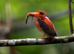
3. The Philippine dwarf kingfisher (Ceyx melanurus) is a species of bird in the Alcedinidae family that is endemic to the Philippines.

4. The Philippine flying lemur (Cynocephalus volans), known locally as the kagwang, is one of two species of flying lemurs, the only two living species in the order Dermoptera. Additionally, it is the only member of the genus Cynocephalus. The other species is the Sunda flying lemur. Recent research from genetic analysis suggests two other species, the Bornean flying lemur and the Javan flying lemur, may exist, as well, but they have yet to be officially classified so. Although called a flying lemur, it cannot fly and is not a lemur. Both species of Dermoptera are classified under the superorder Euarchonta which includes the Scandentia and the primates, as well as an extinct order of mammals, the Plesiadapiformes.

5. The Samar Squirrel (Sundasciurus samarensis) is a species of rodent in the Sciuridae family. It is endemic to the Philippines. Its naturalhabitat is subtropical or tropical dry forests.

6. The Visayan broadbill (Eurylaimus samarensis) is a species of bird in the Eurylaimidae family. It is endemic to the islands of Samar,Leyte and Bohol in the central Philippines.

7. The Palawan flycatcher (Ficedula platenae) is a species of bird in the Muscicapidae family. It is endemic to the Philippines.

8. The Kalinga narrowmouth toad (Kaloula kalingensis) is a species of frog in the Microhylidae family. It is endemic to the Philippines. Its natural habitats are subtropical or tropical moist lowland forests, subtropical or tropical moist montane forests, arable land, pastureland, and plantations.

9. The Mindanao treeshrew (Urogale everetti), also called the Philippine tree shrew, is a species of treeshrew endemic to the Mindanaoregion in the Philippines. It is the only member of the genus Urogale. The scientific name commemorates British colonial administrator and zoological collector Alfred Hart Everett.

10. The Mindoro Black Rat (Rattus mindorensis) is a species of rodent in the family Muridae. It is found only in the Philippines.
10 Endemic Fish Species in the Philippines
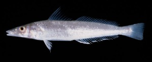 1. Sillago argentifasciata (Silver-banded sillago)
Common name: Silver-banded sillago, Asohos, Ago-os, Alisoos, Asoos, Asuhos, Hosohos, Oso-os, Susay, Usu-us
Environment: Marine, demersal, non-migratory
Resilience: High, minimum population doubling time less than 15 months
Red List Category/Year Assessed: Not Listed
Distribution: Lumbucan Island, Palawan
2. Caelorinchus dorsalis 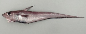
Common name
Environment: Marine, benthopelagic
Resilience: Medium, minimum population doubling time 1.4-4.4 years
Red List Category/Year Assessed: Not Listed
Distribution: Philippines, type locality, northern Luzon
3. Ecsenius dilemma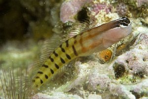
Common name:
Environment: Marine, reef-associated
Resilience: High, minimum population doubling time less than 15 months
Red List Category/Year Assessed: Not Listed
Distribution: Philippines
4. Exyrias ferrarisi (Bia)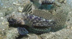
Common name: Bia
Environment: Marine, reef-associated
Resilience: High, minimum population doubling time less than 15 months
Red List Category/Year Assessed: Not Listed
Distribution: Philippines, known only from Bolinao, Pangasinan
5. Gadomus magnifili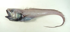 s
s
Common name
Environment: Marine, bathydemersal
Resilience: Medium; minimum population doubling time 1.4-4.4 years
Red List Category/Year Assessed Not Listed
Distribution: Philippines, known from its type locality, off Mindanao in 1,281 m; Sogod Bay, southern Leyte in 1,014 m; and, near Cagayan, Sulu I., Sulu Sea in 930 m
6. Hemitriakis leucoperiptera (Whitefin topeshark)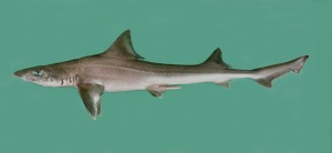
Common name: Whitefin topeshark
Environment: Marine, demersal
Resilience: Low, minimum population doubling time 4.5-14 years
Red List Category/Year Assessed: Endangered/2000
Distribution: Philippines
7. Hypoatherina crenolepis (Crenulated silverside)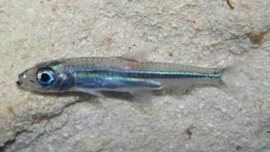
Common name: Crenulated silverside
Environment: Marine, pelagic
Resilience: High, minimum population doubling time less than 15 months
Red List Category/Year Assessed: Not Listed
Distribution: Philippines, Tara and Papatog Islands
8. Solivomer arenidens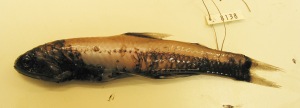
Common name:
Environment: Marine, benthopelagic
Resilience: Medium, minimum population doubling time 1.4-4.5 years
Red List Category/Year Assessed: Not Listed
Distribution: Philippines
9. Stolephorus ronquilloi (Ronquillo’s achovy)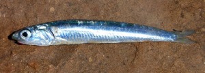
Common name: Ronquillo’s anchovy, Ligbao na lapad, Bolinao, Bulinao,
Burma, Dilis, Muleng-leng, Munamom, Tornos, Tuakang
Environment: Marine, pelagic
Resilience: High, minimum population doubling time less than 15 months
Red List Category/Year Assessed: Not Listed
Distribution: Philippines, perhaps not very abundant
10. Zebrias lucapensis (Darapa)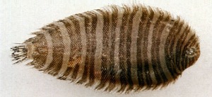
Common name: Darapa
Environment: Marine, demersal
Resilience: High, minimum population doubling time less than 15 months
Red List Category/Year Assessed: Not Listed
Distribution: Known only from Lingayen Gulf, scarce
Our first post
Thank you for passing by! Hope you gain something from our site!
